Using geographic skills to solve real-world problems
Cholera is a severe, infectious disease of
the small intestine. It is marked by heavy diarrhea, vomiting, and muscle
cramps, and can result in coma and death. For centuries, it was confined
to India, but in the early 19th century it began to spread to other parts
of Asia, Europe, and the Americas.
The disease begins in the small intestine,
setting off an infection that interferes with normal intestinal functions.
Frequent diarrhea results. This can cause a great deal of fluid losswater
and essential saltsin a short period of time. In some cases, three to
four gallons of fluid loss has been reported in a 24-hour period. In addition,
vomiting and other symptoms often develop. Unfortunately, about 50 percent
of all those who contract cholera die of the disease.

It is September, 1854, in London, England.
In the past 10 days, more than 500 people, all from the same section of
the city, have died of cholera. Your job is to attempt to determine the
cause of this disease and prevent further deaths. Your only tools are a
knowledge of geography and the ideas of location, place, interaction, movement,
and region. There are a number of competing theories to explain the transmission
of cholera, including claims that the disease is spread through food, water,
air, contact (touch), blood, insects, and animals: nobody knows for sure
where the infection originates or how it spreads.
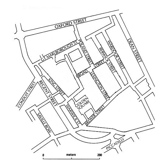
You have a map of the Soho district and
a listing of the approximate addresses of all the dead at your disposal.
Your completed report to the Mayor's office should include 1) a map illustrating
the location of the deaths and any other pertinent information, 2) a written
explanation of the epidemic's cause(s), and 3) a proposed solution. Good
Luck!!
Number of deceased at each approximate location/address:
-
Between Regent St. and Saville Row: 5
-
South of Gt. Marlborough St., east of King
St., and west of Broad St.: 87
-
South of Gt. Marlborough St., west of Poland
St., and north of Broad St.: 43
-
Between Gt. Marlborough St. and Oxford St.:
7
-
East of Golden Square, south of Broad St.,
and west of Lexington St.: 124
-
South of Brewer St.: 12
-
Between Lexington St. and Berwick St.: 112
-
Between Poland St. and Berwick St. (south
of Gt. Marlborough St.): 79
-
Between Poland St. and Berwick St. (north
of Gt. Marlborough St.): 3
-
Between Berwick St. and Wardour St. (north
of Broad St.): 15
-
Between Berwick St. and Wardour St. (south
of Broad St.): 28
-
Between Wardour St. and Dean St.: 48
Locations of selected sites around the City:
-
Churches/Schools: corner of Conduit
St. and Regent St., southern end of Regent St., corner of Regent St. and
Oxford St., Oxford St. and Poland St., corner of Gt. Marlborough St. and
King St., corner of Broad St. and Berwick St., just north of Golden Square,
corner of Lexington St. and Brewer St., center of Wardour St., corner of
Dean St. and Oxford St., and the corner of Dean St. and the northernmost
unnamed street from the west.
-
Food Markets: Corner of Gt. Marlborough
St. and Poland St., between King St. and Regent St., Golden Square, Picadilly
Circus, and the eastern/central portion of Dean St.
-
Hospitals: Between Broad St. and King
St., the eastern end of Oxford St., and between Brewer St. and Picadilly.
-
Water pumps: southern end of Saville
Row, center of Warwick St., corner of Gt. Marlborough St. and the street
going south, between Oxford St. and Gt. Marlborough St., corner of Broad
St. and Lexington St., east corner of Golden Square and Brewer St., corner
of Berwick St. and Brewer St., southern end of Dean St., and the eastern
end of Oxford St.
Map to
use in the assignment |